
Conflict-driven farmland abandonment in Syria leads to land uplift, study finds
The Syrian civil war, which began in 2011, caused widespread population displacement and infrastructure damage. However, it has also led to an unintended environmental effect with notable changes in the country’s landscape, according to a new study published in Geophysical Research Letters. Among the concerns are the complex impacts of wars on water resources. These repercussions can be direct, such as wastewater pollution and destruction of water infrastructure, or indirect, including increased deforestation, soil erosion, and abrupt cropland losses.
Saeed Mhanna, of the University of Neuchâtel, Switzerland, and colleagues highlight how widespread farmland abandonment in Syria and the resulting sudden halt in irrigation allowed underground aquifers to recover and, in turn, lifted the land above them at rates of up to 4 centimeters per year. For a region long stressed by overuse of groundwater, these findings show how human activity—or its sudden absence—can change the Earth’s surface.
Reshaping the landscape
Before the war, northwest Syria’s agriculture relied heavily on groundwater. Intensive irrigation over decades has created deep depressions in aquifers, dried perennial springs, and left rivers running low. Then the conflict forced farmers from their lands, leaving vast tracts of previously irrigated fields untended. Without pumps drawing water for crops, underground reservoirs began to refill.
Satellite radar data enabled the researchers to track subtle movements on the land surface over time. Gathering environmental data in war zones is notoriously difficult as on-the-ground measurements are sparse or non-existent, leaving large gaps in our understanding. Remote sensing, however, provided an unobstructed view from space. By combining Interferometric Synthetic Aperture Radar (InSAR) with vegetation and precipitation data, the team could identify where land surface changes were driven by groundwater recovery rather than seasonal growth cycles or rainfall alone.
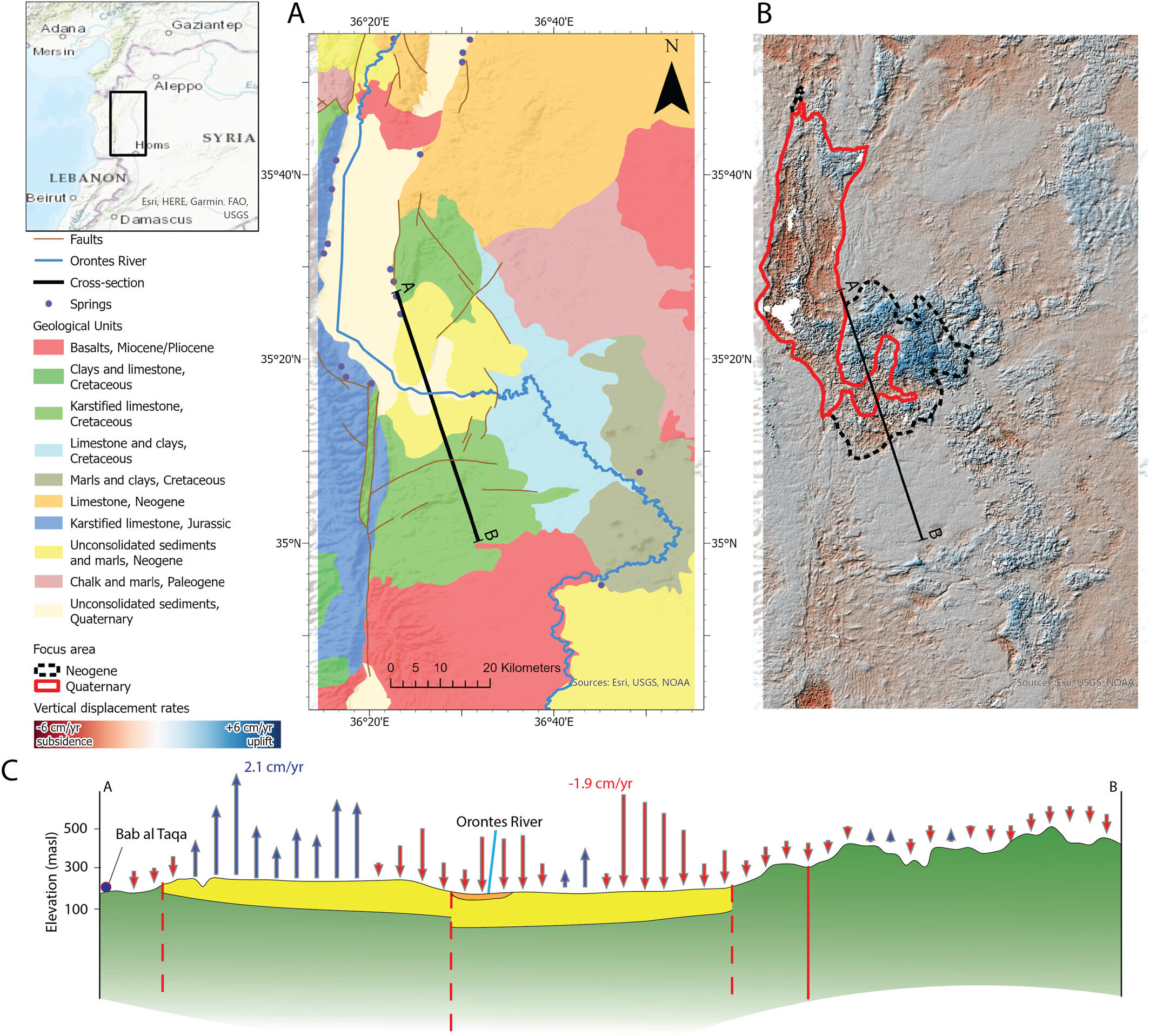
As such, vegetation served as a proxy for irrigation. The team used the satellite-derived Normalized Difference Vegetation Index (NDVI) to measure plant activity. Areas that experienced a sharp drop in summer NDVI that signaled cropland abandonment correlated strongly with upward land movement. Conversely, regions with persistent irrigation, indicated by stable vegetation, continued to experience subsidence.
Croplands on older Neogene rocks (2.6–23 million years old), which sit above soluble limestone aquifers with channels that let water move quickly, showed the strongest land uplift. By contrast, younger Quaternary soils (less than 2.6 million years old) sit on clay-heavy layers that slow water movement, so these areas experienced slower recovery, especially as fields that kept being irrigated continued to subside.
Additionally, river flows increased and some long-dry springs re-emerged. In contrast, areas where pumping persisted continued to sink, illustrating the direct link between human water use and the physical landscape.
Implications for future water management
Groundwater is a critical resource in semi-arid Syria and the study highlights both the risks and opportunities tied to its use. While the war inadvertently allowed aquifers to recover, there is a cautionary note: once irrigation resumes at scale, over-extraction could quickly return, potentially reversing the changes observed during the conflict.
This also illustrates how remote sensing can fill critical gaps in data-poor regions. By analyzing satellite radar, vegetation indices, and precipitation patterns, scientists can monitor groundwater dynamics without relying on traditional field measurements, which are vital in areas where political instability or conflict prevents ground-based observation. The study therefore sets a precedent for using technology to track and manage water resources in regions vulnerable to both human and climatic pressures.
Written for you by our author Hannah Bird, edited by Gaby Clark, and fact-checked and reviewed by Robert Egan—this article is the result of careful human work. We rely on readers like you to keep independent science journalism alive. If this reporting matters to you, please consider a donation (especially monthly). You’ll get an ad-free account as a thank-you.
Publication details
Saeed Mhanna* et al, Rapid Land Surface Uplift and Groundwater Recovery Observed During the Syrian War, Geophysical Research Letters (2026). DOI: 10.1029/2025gl120021
Journal information: Geophysical Research Letters
Key concepts
land use and land coverdeforestationgroundwater and surface-water interactionirrigationsubsidencewater resource management
(https://phys.org/news/2026-04-conflict-driven-farmland-abandonment-syria.html?fbclid=IwdGRjcARMjnNjbGNrBEyOWGV4dG4DYWVtAjExAHNydGMGYXBwX2lkDDM1MDY4NTUzMTcyOAABHh_uBsL1Bsmt5DKAnWosVdxecKz9AMp4kS14i-Md_PxbkCWmRHxccSOgkrK9_aem_L1Wu4mdwmYoE5AJw9qLB9A#google_vignette)
*الدكتور سعيد منير مهنا باحث معتمد في المعهد الفيدرالي السويسري لعلوم وتكنولوجيا المياه، وهو طاقة علمية من لبنان،
روابط صفحات وقنوات حرمون في مواقع التواصل الاجتماعي:
رابط صفحة حرمون في فيسبوك:
https://www.facebook.com/Haramoonplatform
قناة حرمون في واتس:
https://whatsapp.com/channel/0029VbB7xwMGk1FxwxLeLZ0Z
مجموعة حرمون في واتس:
https://chat.whatsapp.com/BAH6v2du3s3BgXoZoV8ViH
https://chat.whatsapp.com/HQi7bkJTOGGLYmdqUsKYOB
حساب حرمون في إنستا:
https://www.instagram.com/haramoon.dxn/
حساب حرمون في منصة إكس:
قناة حرمون في تلغرام:
قناة حرمون في يوتيوب:
https://www.youtube.com/@haramoonplatform
صفحة حرمون في لينكدإن:
https://www.linkedin.com/in/haramoonplatform/
اعلانات حرمون
رفعت لتصميم مواقع الانترنت

منتجات الريان

حرمون معكم دائماً

مزايا إعلانك لدينا

مجوهرات المقت

إعلانات حرمون

إعلانات حرمون